
- What is land subsidence?
- Why Land Subsidence (LS) is important to UNESCO
- What is the UNESCO Land Subsidence International Initiative (LaSII)
What is land subsidence?
Subsidence is one of the most varied forms of ground failure, ranging from borad regional lowering of the land surface to local collapse.
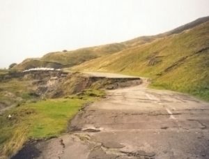
A section of the en:A6187 road, near Castleton, UK, destroyed by geological subsidence. Now permanently closed.
The principal causes of land subsidence are:
- aquifer-system compaction,
- drainage of organic soils,
- underground mining,
- hydrocompaction,
- natural compaction,
- sinkholes, and
- thawing permafrost.
Subsidence (land surface sinking) occurs in many parts of the world, particularly in densely populated deltaic regions, causing extremely expensive damage. Subsidence has resulted from natural causes, such as tectonic motion and sea level rise, from man-induced causes, such as the heavy withdrawal of groundwater, geothermal fluids, oil, and gas, or the extraction of coal, sulphur, gold, and other solids through mining, or underground construction (tunnelling), or from other mixed causes, such as the hydro-compaction of loosely deposited sediments, oxidation and shrinkage of organic deposits, or the development of sinkholes in karstic terrain.
Over 150 areas of contemporary subsidence are known, some with as much subsidence as 10 m in countries such as Mexico, Japan, and the United States. Many more areas of subsidence are likely to develop in the next few decades as a result of accelerated exploitation of natural resources in order to meet the demands of increasing population and industrial development in many developed countries of the world. As developing countries expand their industry, subsidence is likely to occur in many more areas.
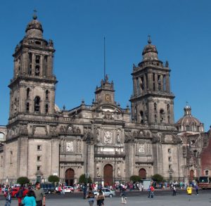
The main Cathedral in Mexico City leans to the left after centuries of land subsidence. Rapid land subsidence caused by groundwater withdrawal and associated aquifer-system compaction has damaged colonial-era buildings, buckled highways, and disrupted water supply and waste-water drainage in Mexico City, Mexico.
Most of the major subsidence areas around the world have developed in the past half century, probably starting to a great extent during World War II and continuing since then, at accelerated rates due to the rapidly increasing use of groundwater and of oil and gas. Most areas of known subsidence are along coasts where the phenomenon becomes quite obvious when the ocean or lake waters start coming further up on the shore. In some such areas, the usually dense population and intensive industrial development are protected from being flooded by several metres of water only by construction of extensive and expensive systems of dikes, flood walls, and pumping stations. The most common subsidence, that due to underground fluid withdrawal, is such a subtle phenomenon — often of large areal extent and at a slow rate — that the problem is not evident in inland areas until new precise levelling takes place or underground pipelines crack, well casings fail or stand above ground level, surface drainage patterns change, or canals no longer carry original design flows.
Developers, as well as the engineers and scientists making the studies and plans for industrial complexes, urban developments, water supply systems, and natural resource extractions need to know about the potential hazards, costs, and socioenvironmental impacts that can result from land subsidence.
Why Land Subsidence (LS) is important to UNESCO
Land subsidence can have significant local or regional impacts. The practical impact depends on the specific form of the surface deformation.
- Regional lowering may aggravate the flood potential or permanently inundate an area, particularly in coastal or riverine areas.
- Local collapse may damage buildings, roads, and utilities and either impair or totally destroy them.
Subsidence is more hazardous to property than to life, because of the typically low rates of lowering. It has caused few casualties. Subsidence, however, increases the potential for loss of life in flood-prone areas by increasing the depth and size of areas susceptible to flooding.
What is the UNESCO Land Subsidence International Initiative (LaSII)
The UNESCO Land Subsidence International Initiative (known as “Working Group on Land Subsidence” until 2018) enhances the scientific understanding and technical knowledge required to identify and characterize hazards related to natural and anthropogenic land-level lowering. LaSII promotes and facilitates the international exchange of information regarding the design, implementation and evaluation of risk assessments and mitigation measures, and the definition of resource-management strategies that support sustainable development in areas vulnerable to land-level lowering. The mission of the United Nations Educational, Scientific, and Cultural Organization (UNESCO) is to contribute to the building of peace, the eradication of poverty, sustainable development and intercultural dialogue through education, the sciences, culture, communication and information. Recognizing that land subsidence is globally prevalent and that much of the subsidence is related to hydrological processes affected by human development of local land and water resources, “Land Subsidence” was included in the United Nations Educational, Scientific and Cultural Organization (UNESCO) programme of the International Hydrological Decade, 1965-1974.