
Recognizing that land subsidence is globally prevalent and that much of the subsidence is related to hydrological processes affected by human development of local land and water resources, “Land Subsidence” was included in the United Nations Educational, Scientific and Cultural Organization (UNESCO) programme of the International Hydrological Decade, 1965-1974. During the Decade, UNESCO organized the First International Symposium on Land Subsidence in Tokyo in 1969. In 1975 land subsidence was retained under the framework of the International Hydrological Programme (IHP) as subproject 8.4 “Investigation of Land Subsidence due to Groundwater Exploitation,” and UNESCO formed the associated Working Group on Land Subsidence.
The first goal of the UNESCO Working Group was to produce a guidebook to serve engineers, geologists and hydrologists confronting land subsidence problems, particularly in developing countries. The volume was published by UNESCO in 1984, and since then the UNESCO Working Group has become the recognized leader in promoting global land subsidence studies, and collaborating with other international scientific organizations to coordinate and host international symposia on land subsidence about every five years.
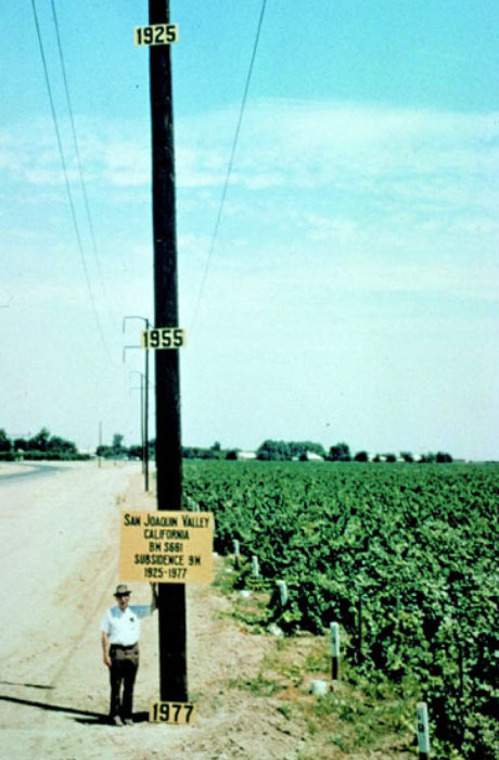
Since the Fisrt International Symposium on Land Subsidence, nine more international symposia on land subsidence have been convened through cooperation of UNESCO with the International Association of Hydrological Sciences (IAHS), and several other agencies and organizations. The proceedings of each of the symposia and the companion publications comprise numerous scientific papers covering the various types of subsidence identified throughout the world. The documents constitute a rich source of research and case studies on subsidence attributed to anthropogenic and natural processes, the development and use of measurement tools such as extensometers, global positioning systems (GPS) and more recently, interferometric aperture radar (InSAR), and the development of mathematical methods and models to simulate flow and aquifer deformation.